|
4:00 P.M.
March 18, 1999
Meeting #1616
Seven Oaks Dam
by William K. Fawcett
Assembly Room, A. K. Smiley Public Library
Biographical Data of William F. Fawcett
o Born July 1923 in New Albany, Indiana
o Grew up in Marion, Illinois
o Graduated from Purdue University with B.S. in Chemical Engineering
o Received MBA from Indiana University
o Served as lieutenant, U.S.Army Ordnance 1943-6 and 1950-1
o Married; three daughters
o Member, Sigma Alpha Epsilon
o Former member, Rotary International
o Former president, Redlands Winter Concert Association
o Member, Board of Directors, Redlands Symphony Association
o Member, Spinet
O Elder, Presbyterian Church
o Long-time choir director
o Development engineer for Marathon Corporation (lster American Can Co., now Primerics) for food packaging
o Manager of new business proposals for the solid rocket propellant division of Olin Corporation 1958-62
o Manager of new business proposals for Lockheed Corporation:
Solid propellant rockets in Mentone 1962-75;
Spacecraft and satellites in Sunnyvale 1975-83
Advanced Tactical Fighter and Skunk Works projects in Burbank 1983-5
o Retired back to Redlands in January 1985
Seven Oaks Dam
Summary
The Seven Oaks Dam is a major element of the Santa Ana River Mainstem Project of the U.S.Army Corps of Engineers, which at $1.3 billion is the largest public works program in the U.S. at the time. The purpose of the Mainstem Project is primarily to protect Orange County from the very extensive flood damage which will otherwise occur in times of heavy rains. The Seven Oaks Dam will function as a large catch basin to control the flow of the Santa Ana River downstream.
The Santa Ana River drains an area of 177 square miles, and is rated by the Corps of Engineers as the greatest potential for disastrous flood damage west of the Mississippi. Several large floods have occurred in the last 150 years, the worst in 1862 and the latest major one in 1969, which caused over $100 million damage, primarily in Orange County.
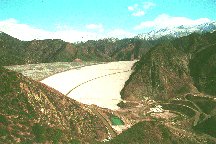
The dam is located near the mouth of the Santa Ana Canyon, just east of Greenspot Road. It is of earth- and rock-filled construction, 550 feet high at the crest and 2600 feet wide. Its slope tapers from 2200 feet thick at the base to 40 feet at the top. Its height ranks among the ten greatest earth-filled dams in the country.
The dam is designed to provide 350-year flood protection and withstand an earthquake of 8-plus magnitude, an important factor because it virtually sits on the San Andreas Fault. During flood conditions it will create a lake 500 feet deep extending 3 miles back into the canyon. The materials for the dam have been obtained at the site: rock from the Santa Ana wash and impervious soil from an old citrus grove southeast of the site and near Newport Road. A total of 42 million cubic yards of material, or over a million truckloads, has been required. An extensive network of conveyor belts has been utilized by the contractor as the primary mode of transport.
The cost of construction is over $250 million. The U.S. Government is responsible for 59% of the cost, Orange County 38%, and Riverside and San Bernardino Counties 3%.
The primary contractor has been OCC Odebrecht Corporation of California, Sherman Oaks, a subsidiary of the Brazilian firm Contructora Norberto Odebrecht. Safety has been an ongoing concern because of the scope of the operation and the equipment involved. An extensive safety program was conducted, but one fatality occurred.
Environmental concerns have caused set-asides of 1500 acres above and below the dam as wildlife habitats.
Introduction
One ot the best-kept secrets in Redlands for a number of years has been the existence of the Seven Oaks Dam. The lights at night have been visible above Mentone for a long time, and more recently the dam itself has been conspicuous from many points in Redlands. Yet there has been relatively little publicity or curiosity about it.
The Seven Oaks Dam is one of nine parts of the Santa Ana River Mainstem Project of the U.S. Army Corps of Engineers; it currently is the largest public works project in North America. The cost of the entire project is about 1.3 billion dollars. The dam's cost is over $250 million.
Purpose
The Seven Oaks Dam is a flood-control dam whose purpose is to contain, as much as possible, the flow of the Santa Ana River during heavy rain storms. In all other conditions there will be no water behind the dam except for the usually insignificant flow of the river. No consideration has been given to recreational use of the dam's facilities because water retained for that purpose would reduce the holding capacity during a flood, and thus tend to defeat the purpose for which the dam is built.
Since we are all quite familiar with the meanderings of the Santa Ana River, and especially its boulders (we've all chuckled about the Mentone Beach), the question naturally arises why a dam and why such expenditure. Many of us are generally aware of the danger because we have seen one or two instances where downtown Redlands and Loma Linda have been flooded by the Santa Ana and its tributaries.
But that isn't the reason for the project. Protection of Orange County from a flood disaster is the real reason for the project. This is borne out by the cost-sharing of the governments involved: the US Government is responsible for 59%; Orange County 38%; Riverside County 2% and San Bernardino County 1%.
As part of the total Mainstem project, the purposes of the Seven Oaks Dam, as given by the Corps of Engineers, are to:
-
keep a 100-year flood in the river channel between Seven Oaks and Prado dams;
-
hold back water until the enlarged Prado Dam and the improved lower river channel have the capacity to hold and convey the water safely to the Pacific Ocean--thereby providing 190-year flood protection in Orange County; and
-
o provide 350-year flood protection at the dam site.
The Corps of Engineers has rated the potential of the Santa Ana River system for disastrous flood damage as the greatest west of the Mississippi because of its large drainage area (177 square miles, the largest drainagebasin in Southern California) and the property values in its flood plain.
What does the data show? There have been 14 "significant" floods in the Santa Ana basin since 1900. The latest one occurred in 1978. The winter of 1969 was particularly rainy. That was the year downtown Redlands and Loma Linda were flooded. The flood by the Santa Ana and all its tributaries caused over $100 million in damage, primarily in Orange County, and provided the impetus for the Santa Ana Mainstem Project, which was authorized by Congress in 1986.. A much greater flood occurred sixty years ago, in 1938. The Santa Ana overflowed its banks in Orange County into what was then largely agricultural areas, inundating them up to 8 feet.
The area's greatest flood on record occurred in January of 1862, one hundred and thirty plus years ago. Persistent rainfall started on Christmas eve of 1861, and continued steadily for 25 consecutive days. On January 18th and 19th of 1862 20 inches of rain fell in a 24 hour period. The river in the Colton area, for example, was three-quarters of a mile wide. No deaths were reported but property damage, even in the then-sparsely populated area, was high.
The Corps of Engineers has based its decision to fund the Santa Ana River Mainstem Project upon the projection of the effect of the 1862 flood, or worse, upon present conditions in the Santa Ana basin. There are three and a half million people living in the 3200 square mile area which would be affected. Over a quarter of a million structures would be threatened, potentially resulting in $15 billion property loss, $14 billion of which would be in Orange County. Angels Stadium, Knott's Berry Farm and the 405 freeway would be under 12 feet of water.
That, therefore, is the rationale upon which the Seven Oaks Dam and its allied sub-projects is based: the fear that if nothing is done to mitigate a future catastrophic flood, the resulting loss of property and perhaps human life would be staggering.
Santa Ana River Mainstem Project
There are six other sub-projects in the Santa Ana River Mainstem Project. Two of them will be briefly mentioned here because of their familiarity to Redlanders: the 2.2 mile Mill Creek levee, completed in 1992 at a cost of $4.2 million, to protect Mentone and Redlands; the other is the enlargement of the Prado Dam, visible on the 91 freeway. The dam, built in 1941, and its spillway will be raised 28 and 26 feet, respectively, to increase greatly its storage capacity in time of flood. This will be the most costly sub-project because $350 million will be required to acquire property for the increased acreage of the holding area.
Site Selection
Among the studies conducted before the start of construction in 1990 was the determination of the location of the Seven Oaks Dam. The selected location is about one mile upstream of the mouth of the upper Santa Ana Canyon, just north of Greenspot Road.
One other location received serious consideration; it is referred to as the Mentone Dam. It was over a mile downstream from the selected location, and was in the flood plain of the river at that point. It would have contained the flow of Mill Creek in addition to the Santa Ana River. Although it would have been less than half the height of the Seven Oaks Dam, it would have required more than 50% more material in order to dam the very wide wash at that point. Cost was the main reason for its rejection.
Seven Oaks Dam
The Seven Oaks Dam is a rock and earth-fill embankment reaching 550 feet above the streambed of the Santa Ana River and stretching over 2600 feet at the crest. The thickness varies from 40 feet at the top to 2200 feet (that's over 0.4 Mile) at the base. The foundation trench on which the dam rests is 80 to 100 feet below the base.
43 million cubic yards of earth and rock are required. That volume ranks about tenth among the dams in the U. S. Its height is about twelfth in the U.S. For comparison its height is one foot lower than the Grand Coulee Dam in Washington and 176 feet lower than Hoover Dam.
The reservoir during flood conditions will cover an area of 780 acres, and will hold 145,600 acre-feet of water. It will be 500 feet deep and extend 3 miles back into two canyons upstream of the dam. Sedimentation over a hundred-year period is projected to reduce the holding capacity to be 200 feet deep behind the dam. Maximum flood conditions are estimated to result in peak inflow of 180,000 cubic feet per second and outflow of 174,000 cubic feet per second.
An earth and rock-filled structure was selected over a rigid concrete design primarily because of the proximity of the San Andreas Fault, which is just a few hundred yards from the downstream base of the dam. The concrete dam was reported to be triple in cost. The dam is designed to withstand an earthquake of 8-plus magnitude resulting in maximum horizontal acceleration of 0.7 g. The dam would experience "just slippage, and would heal itself".
EMBANKMENT ZONES
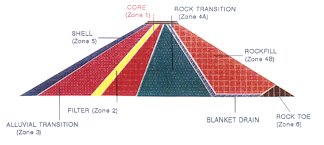 The diagrams show cross-sections of the dam. Upstream is to the left and downstream to the right. The heart of the dam is the impervious core, just upstream from the center-line of the dam. Impervious refers to the fact that when properly moistened and compacted, the core will resist the passage of water. The diagrams show cross-sections of the dam. Upstream is to the left and downstream to the right. The heart of the dam is the impervious core, just upstream from the center-line of the dam. Impervious refers to the fact that when properly moistened and compacted, the core will resist the passage of water.
Early analyses showed that the soil in an old citrus grove about three miles southeast of the dam site, in the neighborhood of Newport Avenue in Greenspot, met the water permeability specification. Five million cubic yards, the equivalent of 150,000 truckloads, come from that source.
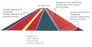
SOURCE MATERIAL FOR EMBANKMENT
The more than thirty-five million cubic yards of pervious materials will come from the dam site itself and from the riverbed below the Greenspot Road, about half from each source.
The information below (Zone Material and Purpose) gives the characteristics of the materials shown in the upper half of Figure 1. The negative sign preceding the numbers indicates that the material will pass through a screen with a hole that size. It is interesting to observe that the size of the river rock varies from 4 foot boulders in the rock toe to less that 2-inch gravel and sand in Zone 2. Also note that 12 to 36 inch rock, called armor stone, is used to protect the most vulnerable part of the dam, its upstream face. Those who have toured the site during construction have observed the monumental scope of rock crushing which has been necessary to achieve the required distribution of sizes from the large boulders in the wash.
ZONE MATERIAL AND PURPOSE Alluvial material (River Rock)
Armor Stone = 12 to 36" rock (is used to protect As face of dam) (PB)
Zone 5 = -12" Crush rock (Protection & Draw Down lowering the water level quickly). (PB)
Zone 3 = -12" rock gravel and sand (Transition zone between zone 5 and core material). (PB)
Zone 2 = Filer -2" gravel and sand (Crack stopper in case of earthquake) (PB)
Zone 1 select = is used at very base of dam next to rock material. Zone 1 common = is used on the other areas of the core Core material (clay material restricts water penetration thru the dam) (UPB)
Zone 4A = - 9" max rocks (serves as back stop on dam) spillway & gov. ridge
Zone 4B = - 15" max rocks (same as 4A material) spillway & gov. ridge
Blanket Drain = -2" gravel (Control seepage that should pass thru dam and off the abutments) (PB)
Rock Toe = up to 4' boulders (stability) (PB)
Zone SCA = -12" crush rock (erosion control) (PB)
Impervious Borrow - Clay = Smillion cy about (150,000 truckloads) core of dam Pervious Material + 12 million cy about (350,000 truckloads) zone 3, zone S. blanket drain, Armor Stone. Spillway & Government Canyon 17 million cy (660,000 truck loads from dam site. Total fill 40 million cy to complete dam.
A 500-foot wide spillway 30 feet below the crest of the dam and about 1700 feet east of the dam will provide overflow capability by draining the excess into Deer Creek and thereby protecting the top of the dam from erosion.
One of the early contracts let by the Corps of Engineers was awarded to Tutor-Saliba for the construction of the outlet works tunnel. The design was based upon a feasibility 1:25-scale study done by the Corps' Waterways Experiment Station at Vicksburg, Mississippi. The award was for almost $20 million. The tunnel is 1656 feet long by 18 feet in diameter, and is lined with thick reinforced concrete walls. It penetrates the mountain on the east side of the dam at streambed elevation and drops 50 feet to its discharge end. Its functions are to divert normal river flow during construction and to regulate discharge flow during flood conditions. For about 1000 feet of its length the tunnel is circular. There the cross-section changes to horse-shoe shape by the construction of a reinforced concrete "shelf" at the center of the bore to permit access by golf carts to service a flow-control gate. Air is introduced there to prevent water in the tunnel from cavitating. A 360-foot air shaft 10 feet in diameter has been drilled from the top of the mountain to supply the air.
Water enters the outlet tunnel from a 210-foot intake tower intended to prevent sediment from entering the tunnel. Maximum flow velocity through the tunnel is 200 feet per second. The discharge capacity is 7000 cubic feet per second. The tunnel discharges into a rip-rap lined plunge pool to help dissipate the kinetic energy of the water before it enters the river.
Among the most important decisions the contractors bidding for the dam proper had to make was the choice between earth-mover trucks and conveyor belts. The more than 40 million cubic yards of earth and rock which had to be moved would require more than 1.5 million truckloads by very large earth-movers. About 1 million cubic yards must be placed each month to meet the schedule. While the inclines from the two main sources of earth and rock to the foot of the dam are not severe, the grade becomes very steep to place the materials at the construction level as the dam rises, and would undoubtedly result in the use of numerous switch-backs for the trucks to reach the working height, up to 550 feet. This would be very costly in terms of labor, fuel and maintenance.
The winning contractor based his bid on the installation and operation of extensive conveyors throughout the construction area. The conveyor belts are 60 inches wide. The longest is 3 1/2 miles. A total of 8 miles have been installed, and their operation has been one of the highlights for visitors touring the facility. From the streambed elevation each of two conveyors carries earth and rock, a total of 3200 tons per hour, to the working level, where the materials are dumped and transported to the working area by large earth-movers.
As construction has reached significant heights, the grade of the conveyors became very steep, but they have performed as expected. Feasibility of their use was confirmed by a prior study by the Los Angeles firm of Gannett Fleming under contract to the Corps of Engineers.
Electric power for the project is provided on site by 16 natural gas generators, each producing 450 kilowatts. The project buys about $80,000 of gas from the Southern California Gas Company per month. The electricity generated powers the conveyors, the large rock crushers, lights for the night shift plus miscellaneous uses.
The project has contracted with the San Bernardino Valley Municipal Water District to supply water for the two principal uses, soil compaction on the dam and dust abatement throughout the entire construction area. About 17 million gallons per month have been required.
The contractor for construction of the dam embankment is OCC Odebrecht Contactor of California, Sherman Oaks, a subsidiary of the Brazilian firm Construtora Norberto Odebrecht, based upon its low bid of $167.8 million in 1993. The bid was $36 million below the Corps' estimate, and almost $60 million lower than the second low bid. Award of the contract to OCC was held up for a year while two protests by the second-low bidder were evaluated and then denied.
Construction on the dam began in August of 1994, with completion scheduled in August of 1999. Crews have worked two ten-hour shifts per day, six days a week, with the last four hours per day and Sundays devoted to maintenance. Peak employment has been 379 construction workers plus 50 supervisory and quality control personnel. In addition there have been about 38 people assigned to the local office of the Corps of Engineers overseeing the project.
The quality control staff was responsible for insuring that the materials and workmanship for each of the zones of the dam met the criteria specific to that zone. All tests were performed to ASTM standards. Among the tests which were conducted regularly during construction were: compaction; moisture; gradation; ring; sand cone; specific gravity; Proctor; and 27-inch lab mold.
One of the biggest concerns of both the contractor and the Corps has been worker safety because of the size and scope of the operation and the terrain. 3,279,204 man-hours have been worked to date, at a very low lost-time accident frequency rate of 0.67, compared to the national frequency rate for similar work of 10.6. These values are calculated by the formula: number of lost-time accidents times 200,000 divided by the number of man-hours worked. The contractor maintained an aggressive program for worker safety by providing incentives for attainment of no-lost-time goals. Unfortunately one fatality occurred in spite of an otherwise very successful safety program.
Blasting has regularly been used to loosen earth and rock to facilitate loading onto the conveyor belts by very large earth movers. The contractor has used 9 Caterpillar Model 777s earthmovers, which weigh 60 tons and transport 90 tons, for most of the project. Toward the end 9 Euclid Model R90 were utilized; they weigh 90 tons and carry 110 tons. These two earth mover models cost $550,000 and $653,000, respectively. Their movement at high speed around the area coupled with the traffic caused by other construction and supervisory vehicles creates a high potential for accidents.
For the last one hundred years the Southern California Edison Company has operated three hydroelectric generating plants in the lower Santa Ana River canyon. They are fed by river water carried in flumes along the canyon wall. Plant #1 was built in 1899 at a point sufficiently upstream of the dam that it will not be affected. Plant #3 is located downstream of the dam, so it too is not affected. Plant #2 is located a short distance upstream of the dam, and it has been destroyed.
Another of the major concerns of the Corps of Engineers and therefore each of the contractors has been the potential damage to the ecology of the area by such a massive construction effort. This paper is written as construction of the dam is nearing completion, at a time when dams across the United States are coming under scrutiny for the damage they have done to aquatic life, particularly to the spawning runs for fish. Two such dams have been in the news recently: one in upstate Maine is being demolished to return its river to the natural state; the other is in northern California, where demolition is being considered. Since the Santa Ana River is not the long migration route for spawning fish, nor is it the habitat for many endangered species, its potential for impacting the ecology is not great.
Nevertheless, the Corps of Engineers has been very concerned about its responsibility to the environment, and has worked closely with the U.S. Forest Service and the U.S. Fish and Wildlife Service to incorporate environmental features to offset environmental losses due to dam construction. The results are the preservation of the following acreage for wildlife habitats:
-
138 acres at Filaree Flats, about three miles upstream of the dam, for riparian, aquatic and upland habitat;
A trade-off was negotiated by Congressman Jerry Lewis with the Fish and Wildlife Service on January 27, 1998, to preserve an additional 60 acres in the downstream borrow site to compensate for the potential loss of habitat for the San Bernardino kangaroo rat, a species on the endangered list.
The contractor will be responsible at the completion of construction for restoring the entire area to its original condition and appearance, or as close to it as the changed topography permits.
|