MEETING # 1597
4:00 P.M.
February 5, 1998
The Earth's Version of
the Old Bump and Grind:
Plate Techtonics
by Allan D. Griesemer Ph.D.
Assembly Room, A. K. Smiley Public
Library
ABSTRACT
Geologists have felt for some time that their discipline doesn't receive
its share of public support, since it is a relatively low profile science. Several
geologists tried to stir some financial and public interest in their science following
W.W.II with a proposal to develop a project to drill a hole through the Earth's crust and
into the mysterious realm below, referred to as the mantle. After a rather positive start
the project,called "Mohole", died of poor planning and huge cost overruns.The
concept, however, was a good one, for it is now known that the key to understanding how
our planet functions, lies with a better understanding of the Earth's outer skin, at least
the outer 150 klm.
Since W.W. I-I, much work in this area has been done, although we have yet
to hold rocks from these depths in our hands. This sub-discipline of geology is now called
plate tectonics, which refers to the creation and destruction of the major structural
elements of the Earth's surface and their roots.The old breakdown of the Earth's interior
which included the crust, mantle and core, has been refined to include a much more complex
picture.
This picture now includes a lithosphere (the upper 100 Kim), and
asthenosphere (the next 100 klm). The lithosphere is viewed as a solid mass that moves
about the planet a series of plates riding on a less solid asthenosphere.The lithosphereic
plates are felt to be created along breaks in the surface, where outpourings of lava
occur, and are destroyed as the plates dive under neighboring plates at deep oceanic
trench margins. In this theory, the continents are simply being carried along on the
lithosphereic plates like objects on a conveyer belt. This concept was initiated as a
serious concept by Alfred Wegener in 1912, but was strongly rejected by especially
American geologists until after W.W. II, when the evidence became very strong.
The new evidence includes a world wide ridge and valley system in the
oceans, paleomagnetism, the youthful age of the Atlantic and other oceans, the actual
measurement of plate movement,the alignment of most volcanoes and earthquakes along known
plate boundaries, and the fact that this theory unifies geologic thought like no other,
and it has provided substantial insight to a myriad of previously unanswered questions.
However, many questions still remain, for the mechanism that allows or causes the plates
to move is still only conjecture. Perhaps the Mohole project should be reactivated.
ABOUT THE AUTHOR
The author has recently retired as the Director of the San Bernardino County Museum,
having served in that profession for thirty six years. He started out as an apprentice at
the Newark Museum in Newark, New Jersey, spent three years at the Dayton Museum of Natural
History and nineteen years at the University o:. Nebraska State Museum in Lincoln. He
received his AB at Augustana College in Rock Island, Illinois in 1959, his MS at the
University of Wisconsin in 1963, and his Ph.D. at the University of Nebraska in 1970. He
has published 23 museum related articles and eight academic papers. He is a member of
several community based non-profit organizations r and maintains his membership is such
national organizations as the National Trust for Historic Preservation, and Sigma Xi. He
is married and has three sons living in the Midwest.
The Earth's Version of the Old Bump and Grind:
Plate Tectonics
Introduction
From it's inception as a modern science, geology has always been fueled by economics, a
concept that still holds today. This is hardly surprising since the discipline is
intimately associated with the location, understanding, and ultimate use and extraction of
the Earth's crust bound natural resources. With such a basic and critical purpose, one
would hardly anticipate that a science of this kind would be considered unimportant enough
to be excluded from any major government's list of supportable endeavors. However, in our
government's current budget year list of possible cuts, the one hundred and nineteen year
old United States Geological Survey was mentioned for potential elimination! All of us in
the profession were shocked, but probably not so the general public, for you see, geology
is not a very exciting, headline-grabbing science; we didn't, until recently anyway, send
people into outer space, frolic with whales, or find previously undetected tribes in
Borneo - we collect rocks.
This concern was acutely noted in the profession following World War II, for as many of
you know, this was a period when scientific endeavors found considerable support from our
government and many other granting agencies. Money for scientific inquiry and exploration
was free flowing in those twenty or so years following the war, but geologists in general
felt they were being left out of the loop, because their endeavors just didn't have the
public appeal of other sciences, especially those darn space exploration people! This
issue was given an opportunity to rise to the surface in 1957 when a panel of reviewers at
NSF lamented the fact that most of the proposals coming before them did not show any
"courageous attempt to break new ground". Two of the reviewers were geologists,
so between these two they decided to push for the creation of a sub-crust sampling
program, something which had not been done (and still has not). They felt this would give
the discipline just the type of stride forward needed in the physical sciences. They
noted, "think of the attention it would attract to the earth sciences, a perfect
anti-analogy to the space program".
To make a long story short, their fantasizing eventually became the Mohole project and
was actually funded in the early 60's, but ran into a lot of cost over-runs (a 1.7 million
estimate in 1961 became 100 million in 1966) and political problems (the contract went to
a Texas firm while Johnson was President). The actual funds expended amounted to about 36
million before the plug was pulled in May of 1966. However, many advances were made,
especially in the area of deep sea drilling (which was the technological heart of the
program) and the project realized 103 inventions, many of which were patented.
The point of this seeming digression was to emphasize that the earth sciences, although
sound and basic to our existence as those needs relate to natural resources, is not well
understood or appreciated by the general public - which is one reason I was so compelled
to chose this topic to present to this august group today.
This brings me to the setting of the stage for the major topic of this presentation -
plate tectonics, which has considerable potential to attract public attention, after all,
it suggests that the ground beneath our feet is anything but solid, regardless of where
you may live on this planet! Tectonics is derived from the Greek word "tekton'' to
build, and in geology is considered as the study of the formation and deformation of the
Earth's crust, especially in relation to large scale structures. Thirty years ago, large
scale structures meant to geologists, stable continental interiors called cratons, and
much less stable continental margins, where many of our mountain ranges are found today.
These less stable areas were thought to be accretionary suggesting the Earth's continents
grew from their centers outward.
Today, this exciting area of geology paints a much different picture, suggesting
instead of immobile continents somehow anchored to the Earth's interior, an exterior layer
of rock up to 100 Kim thick, sliding around on a second subcrustal, almost mushy layer,
that geologists feel is also about 100 klm in thickness. In addition, the whole surface is
not moving as one large mass, instead it is broken into large chunks called plates, ten to
twelve major ones and several minor ones. This revelation has generated a truly exciting
new picture for geologists, in fact plate tectonics has resulted in the discipline's first
substantial unifying theory - making it as important as evolution was for biology, but
coming to the fore almost one hundred years later.
To put plate tectonics in perspective, one must have a reasonable understanding of how
geologists picture the interior of the Earth, and equally important, the nature of the
internal engine that throbs at the core of our planet.
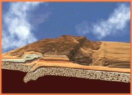
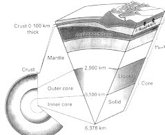 To assist in this effort please observe the Figure which provides a very
general picture of the Earth's interior as currently understood. The Earth is classically
believed to have three major zones, the core, mantle and crust. The core is believed to be
about 3500 klm thick, the mantle about 2800 klm thick and the fragile crust up to 100 klm
in thickness (being thickest under mountain ranges). These numbers are derived primarily
from the work of seismology, and some knowledge of rock types and their densities taken
from actual rock samples of the crust and perhaps even the mantle. From this Figure it is
also possible to note that the crust varies considerably in thickness between the ocean
and the land, (10 to 15 Kim under the ocean to 100 klm under the tallest mountains; which
is why the Mohole project was going to be attempted in the ocean). To assist in this effort please observe the Figure which provides a very
general picture of the Earth's interior as currently understood. The Earth is classically
believed to have three major zones, the core, mantle and crust. The core is believed to be
about 3500 klm thick, the mantle about 2800 klm thick and the fragile crust up to 100 klm
in thickness (being thickest under mountain ranges). These numbers are derived primarily
from the work of seismology, and some knowledge of rock types and their densities taken
from actual rock samples of the crust and perhaps even the mantle. From this Figure it is
also possible to note that the crust varies considerably in thickness between the ocean
and the land, (10 to 15 Kim under the ocean to 100 klm under the tallest mountains; which
is why the Mohole project was going to be attempted in the ocean).
You will also note from the figure that there is another designation given to a segment
of the upper portions of the Earth, the asthenosphere and the lithosphere. The lithosphere
actually includes several klm of upper mantle as well as the crust. The reason they now
are coupled by geologists is that they act together, structurally speaking they move
together. The boundary between the crust and the mantle is based on compositional
differences in rock types, and it was this boundary between the mantle and crust that the
Mohole project was going to attempt to penetrate, and as I noted earlier, it still has yet
to be done. What they didn't realize in the 1960's is that a much more interesting
boundary is the lithosphere/asthenosphere boundary, for it is here that most of the
critical action for plate tectonics occurs.
The asthenosphere (which means 'weak sphere') is now believed to be a 100 klm thick
layer that acts like a semi-plastic lubricated zone that allows the lithosphereic bound
plates to move about. It is believed, the reason for its existence is that in this 100
klm, a balance exists between pressure and temperature allowing for partial liquidity.
This movement it is believed, is generated by the action of the Earth's internal engine,
the heat generating radio-active minerals of the mantle and core. In other words, this
boundary is based on mechanics rather than composition.
II. The Growth of a Concept
Not only did geology need some assistance to attract public support in the 60's, its
need actually went much deeper - it had never developed a unifying theory that would allow
the numerous sub-disciplines to interact productively to solve the ever increasingly
complex problems that were coming before the profession. As noted above, plate tectonics
finally gave them a framework, but just as the concept of evolution, it's acceptance did
not come easily. An abstracted history of that effort follows.
Francis Bacon in the 17th Century and several early cartographers and explorers,
including Alexander Von Humboldt, for some time had made note of the apparent
"fit" between Africa and South America, but only the most daring would suggest
that the two at one time had split apart! The first to put this idea in print was Antonio
Pellegrini in 1858. He suggested that all continents were at one time together, but had
been split up by the impact of the Noachian Deluge. A bit more scientific hint concerning
the mechanism came from a German, Osmond Fisher, who in an 1880 treatise suggested, much
ahead of his time, that the Earth had a liquid core complete with convection currents.
Thoughts of mobile continents fell on much more sympathetic ears in Europe. These people
were called "mobilists".
On our side of the Atlantic this concept was given little credence, so the
immobile-continent position holders were called "stabilists". Strangely enough,
considering this geographic split, the next serious consideration of this concept was
given life in this country in 1908. The suggestion was made by F.B. Taylor and later
supported by another American, H.H. Baker. They suggested the apparent fit of the two
southern continents could suggest they were torn apart by some dramatic event such as the
close passage of a large celestial body (planet or Moon). Even though this rejuvenation
started in America, the main interest for this idea remained based in Europe and South
Africa, and was mostly ridiculed by scientists in the America.
In this early period, the Americans primarily followed the theories of Eduard Suess, an
Austrian, who suggested in 1904 that the Earth's crust was the product of a gradually
cooling planet, with the mountain ranges and ocean basins forming as the crust shrank. He
felt that as this process developed, a large uplifted continental area was created, which
he called Gondwanaland. He went on to suggest that subsequently, sections of this massive
continent collapsed forming some ocean basins.
Suess's theory, which became the dominant theory in the profession in the early 20th
Century was not acceptable to a German meteorologist by the name of Alfred Wegener.
Wegener strongly revisited the concept of splitting continents in a lecture in 1912, and
in printed form in 1915. In fact he went a step further and suggested the concept of
"continental displacement", later referred to as "continental drift".
His premise was based not only on the intriguing fit of the southern continents, but also
on similar rock types, geologic structures, and fossils found on the opposing margins of
these land masses. He didn't stop there, he further suggested that all the continents were
massed together as one land mass about 200 million years ago, which he called
"Pangaea". This publication was not translated into English until 1924 so it did
not get much reaction on this side of the Atlantic until that time.
Also about this time, the concept of a shrinking Earth was losing support due to the
recognition that radioactive decay was more likely than not the major source of the
Earth's internal heat and therefore, the Earth was not cooling as fast as earlier thought.
This revelation was followed by the suggestion from the highly respected Sir Arthur Holmes
in 1929, that this newly designated heat source could be significant enough to produce
convection currents in the Earth's mantle, confirming the earlier proposal of Fisher.
However, a year earlier, in 1928 the formidable U.S. geologic community came out with a
compendium publication which issued a scathing attack on not only the idea of mobile
continents, but also the newest proponent, Alfred Wegener. Since he was "only" a
meteorologist, they suggested with not much subtly, that he was a quasi-scientist, who
played very loosely with superficial facts, in a discipline in which he knew little.
Wegener, apparently overwhelmed by the severity of this attack, chose to withdraw from the
issue, suggesting in his last publication in 1929, that all disciplines needed to work
together to truly understand the complexity of these issues. The only other support for
the theory prior to World War II came in 1937 from a South African geologist, Alexander du
Toit. He based his support primarily on the amazingly similar geology and paleontology on
both sides of the frantic, offering considerably more well documented data on which to
base his position. He also was the first to speak of a subsequent break-up of Pangaea into
two major masses, the northern one he called Laurasia, and the southern one Gondwanaland.,
with a new ocean forming between them called the Tethys Sea (see Figure below).
However, with the initiation of World War II, this whole controversy was put on hold, and
did not resurface until the early 1950's.
Ever since the 16th Century, the ocean floor was known not to be a
featureless plain. However, it wasn't until 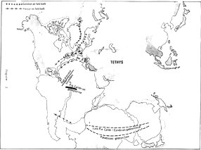 the 19th Century with the advent of the first
trans-Atlantic cables that we began to understand the structural complexity and ruggedness
of our ocean floors, which were still mostly a mystery to science. The first charts,
showing mountain size masses on the sea floor, were provided in 1855 with the work done by
a Lt. Matthew Maury of the U.S. Navy. the 19th Century with the advent of the first
trans-Atlantic cables that we began to understand the structural complexity and ruggedness
of our ocean floors, which were still mostly a mystery to science. The first charts,
showing mountain size masses on the sea floor, were provided in 1855 with the work done by
a Lt. Matthew Maury of the U.S. Navy.
Following World War II, much of the data obtained by the Navy, and other sources,
including, soundings, seismological work, and ocean floor sampling was made available to
scientists, which spurred a great deal of interest in what was happening geologically
beneath those mysterious ocean floors, and the revelations were amazing. Not only did they
learn a great deal more about the ocean floor relief, they also found out that the ocean
floor sediment was not very thick, certainly not thick enough to suggest the oceans had
been in place for billions of years.
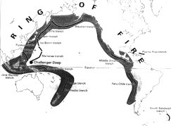 In
addition, one geologist, Hugo Benioff, recognized in 1949, that all the deep earthquakes
(up to 700 klm) and 82% of all earthquakes, for no apparent reason, arranged themselves in
curvilinear patterns, mostly around the margins of the Pacific Ocean. Since our planet's
hottest volcanic belt seemed to parallel this earthquake path, it was designated the
"Ring of Fire" (see Figure at left). In
addition, one geologist, Hugo Benioff, recognized in 1949, that all the deep earthquakes
(up to 700 klm) and 82% of all earthquakes, for no apparent reason, arranged themselves in
curvilinear patterns, mostly around the margins of the Pacific Ocean. Since our planet's
hottest volcanic belt seemed to parallel this earthquake path, it was designated the
"Ring of Fire" (see Figure at left).
During the 50's, as more and more exploration into the ocean's greatest depths
occurred, it became clear that there was a series of ridges that ran through the ocean
system that appeared to be connected, which we now call the mid-oceanic ridges as seen in
the figure at right. These interconnected ridges are about 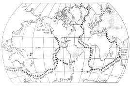 50,000 klm long, average one
to three klm high, are up to seventeen hundred klm wide, and include a mid-ridge valley up
to one klm deep. In addition, the 1920 discovery of paleomagnetism in rocks was found to
have an application in this controversy. This concept indicates that when rocks form, the
grains of which they are made align themselves with the north magnetic pole as the rock
solidifies. The alignment of these grains not only indicate the direction north at the
time of their formation, they also suggest their latitude, based on their inclination at
the moment their enclosing rock solidified. This initially caused considerable confusion
since the trapped magnetism in rocks from different parts of the world often didn't line
up with the Earth's current pole, suggesting polar wandering had occurred throughout
geologic time, but how and why? 50,000 klm long, average one
to three klm high, are up to seventeen hundred klm wide, and include a mid-ridge valley up
to one klm deep. In addition, the 1920 discovery of paleomagnetism in rocks was found to
have an application in this controversy. This concept indicates that when rocks form, the
grains of which they are made align themselves with the north magnetic pole as the rock
solidifies. The alignment of these grains not only indicate the direction north at the
time of their formation, they also suggest their latitude, based on their inclination at
the moment their enclosing rock solidified. This initially caused considerable confusion
since the trapped magnetism in rocks from different parts of the world often didn't line
up with the Earth's current pole, suggesting polar wandering had occurred throughout
geologic time, but how and why?
The story got even stranger in the late 50's and early 60's when samples from the
oceanic ridges turned out to suggest polar reversals had occurred, and that the parallel
ridges found on either side of the central valleys were mirror images of each other, not
only in magnetic reversals, but also in age (see figure at left)! Further study revealed
that the ages of the rocks on 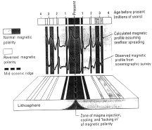 either side of the main valley increased outward, being very
young adjacent to the ridge and progressively older as samples were taken closer and
closer to the ocean's margins. These reversals have now been recorded from the central
valley in the Atlantic to the North American coastline, and have been found to occur on
the average about every one million years. The last one occurred about 730,000 years ago
so perhaps we should be prepared - but for what? No one seems to know. either side of the main valley increased outward, being very
young adjacent to the ridge and progressively older as samples were taken closer and
closer to the ocean's margins. These reversals have now been recorded from the central
valley in the Atlantic to the North American coastline, and have been found to occur on
the average about every one million years. The last one occurred about 730,000 years ago
so perhaps we should be prepared - but for what? No one seems to know.
As this astounding mass of new information flooded into the laboratories of two U.S.
researchers of the time, R.S. Dietz and Harry Huss, a new and very exciting picture of the
Earth's geology began to emerge. These gentlemen proposed a totally new concept called sea
floor spreading which they coupled with the old idea of convection currents to account for
these new revelations. Other geologists who had spent their lives studying earthquakes and
volcanism also noted about the same time, that the foci of the Earth's major quakes and
volcanic chains were centered along these same ridges, related fault zones and island
chains, which fitted very well with the Benioff revelations of the previous decade. But
did this mean the Earth was expanding? Such a concept was hard to swallow.
All of this led ultimately to the idea of mobile plates that are constantly growing
along the valleys, but also being consumed along major fault/volcanic zones often
associated with deep oceanic trenches, now called subduction zones which usually are
situated adjacent to continents. In other words, plates are constantly developing and
being destroyed, and the continents ride along as if they are on a conveyer belt, which
allows the Earth to remain constant in size. The growth occurs along what are now called
divergent boundaries, and the consumption along convergent boundaries. They also
recognized that this major  plate system encompasses the entire Earth (see figure at right).
Many questions seemed to find answers with this blend of old and new ideas, and at the
same time gave geologists a very exciting new view of the planet, including its age,
internal dynamics, and rationale for all known surface features - it all began to fit
together. plate system encompasses the entire Earth (see figure at right).
Many questions seemed to find answers with this blend of old and new ideas, and at the
same time gave geologists a very exciting new view of the planet, including its age,
internal dynamics, and rationale for all known surface features - it all began to fit
together.
III. The Current Plate Tectonic Theory
Even with all the new data becoming known during the 1960's, there were still many
geologists who doggedly refused to believe that continents had been moving about the
planet for billions of years. But by the 1970's the evidence was incontrovertible. During
this decade they were actually able to measure the movement - one to eighteen centimeters
per year, and technology had allowed us to visit the deep sea floors, and actually see the
basaltic lavas pour out onto floors of the central valleys.
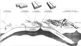
The figure above gives a good general picture of the concept of plate tectonics. It all
starts with the seven thousand degree centigrade furnace at the core of our planet. The
heat from this internal engine is crucial to the continual operation of the Earth's basic
machinery. The current theory recognizes three major types of plate boundaries, all of
which are pictured in the figure above Divergent, Convergent, and Transform boundaries.
Divergent Boundaries
This is where it all starts. The heat of the Earth's interior creates convection
currents in the semi-plastic mantle, which the aforementioned Harry Hess felt last for
2-300 million years. As these flows impinge on the thin upper layers, they cause a bulging
upward which thins the lithosphere, and with time causes it to break. With this thinning
and weakening of the lithosphere, the more dense mantle rocks push upward, and with the
corresponding lessening of the overlying pressure, liquefy and the basaltic magmas push to
the surface erupting as lava flows in these central valleys. In the oceans, these lava
flows eventually build up to a mile in thickness and split, with half going to either side
of the rift. This accounts for the equal age and polarity of the basaltic lavas on either
side of the central valley. This happens more in the oceans than on land for the ocean
lithosphere is much thinner. However, this phenomena does occur on land as well, in fact
some geologists believe the Yellowstone area may be just such a site. It is felt that
these divergent zones develop initially as hot spots that reach the lithosphere as
individual mushroom shaped plumes, several tens of KLM across. With time, the initial
plume may be joined 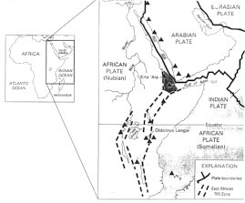 by others, forming an embryonic ridge and valley system. In addition to the
Yellowstone potential, geologists feel another site that passed the individual plume stage
about 30 million years ago, can be found in east Africa at the juncture of the Red Sea,
the Golf of Aden, and the east African rift valleys (see figure at right). by others, forming an embryonic ridge and valley system. In addition to the
Yellowstone potential, geologists feel another site that passed the individual plume stage
about 30 million years ago, can be found in east Africa at the juncture of the Red Sea,
the Golf of Aden, and the east African rift valleys (see figure at right).
This theory suggests such sites usually form a tri-star pattern, with one branch
ultimately "freezing" and the other two developing into a new ridge system,
which seems to be the case in Africa. They feel other examples of this include the
break-up of Africa, Europe and North America 200 million plus years ago, with the frozen
branches becoming major river systems such as the Mississippi' Niger, and Amazon. Another
famous hot spot currently is the Hawaiian Island chain which in reality is 6000 klm long
called the Hawaii - Emperor chain. Someone has figured this chain has already experienced
an outflow of over 750,000 cu klm of lava. The Pacific Plate is moving northwest,
therefore the northwest Hawaiian Island, Kanai, is 5.5 million years old, and Hawaii is
only .7 million years old. Since this plate has continued to move Hawaii has actually
slipped beyond the major plume, and a new sea mount, Loihi, is forming 3.5 Kim southeast
of Hawaii and is already 3 klm high and only 1 klm from the surface. Soon, in geologic
terms, there will be more real-estate available!
Transform Boundaries
These boundaries represent areas where two plates are sliding past each other. The
fault in a sense transforms the motion of one spreading center to an adjacent spreading
center, and the only motion along the fault is between the spreading centers. It is felt
that these cut off pieces of spreading centers were never together, but act as pieces of a
continue. The reason they form in pieces, it is believed, is because mechanical
constraints prevent divergence to proceed along a longitudinal curve, therefore the
centers split into a series of non-curved segments. These faults were first described by
J. Tuzo Wilson from the University of Toronto in 1965.
Of course, the most famous transform fault is the San Andreas (see figure at left)
which transforms the spreading motion of the Pacific Rise spreading zone to what is left
of the rapidly disappearing Juan de Fuca spreading zone. This action is causing the
Pacific Plate to move past the North American Plate at about 5 cm per year, which will put
Los Angeles opposite San Francisco in about 10 million years.
Convergent Boundaries
The concept of large segments of lithosphere running into each other has answered a
great many questions regarding the existence and positioning of oceanic trenches as well
as land and ocean based mountain systems, and their associated earthquakes and volcanoes.
A review of Figure 8 gives a good visual argument for this concept. Of course, as the
ocean basin begins to widen, it is going to put pressure on the margins. It could
gradually push the continental mass away, which is called a passive continental margin,
such as the east coast of North America. In this case, the distance between the Atlantic
rift zone and North America represents a complete accumulation of spreading zone lava
flows, with the oldest being up against the North American continental shelf, and the
youngest at the edge of the spreading zone itself. That difference is just about 180
million years, in other words, there are no rocks on the floor of the Atlantic Ocean older
than 180 million years, which was quite a revelation at the time of its discovery.
However, if the pushing plate is oceanic, it more often than not will slide beneath the
continental plate, for the continental rocks are lighter even though they are thicker.
This action is called subduction, which I mentioned earlier, and will proceed to a depth
of at least 700 klm. The reason they know they reach this depth is that is as deep as
earthquakes are known to occur. In other words, beyond this depth, the subducting rocks no
longer are brittle enough to crack and separate into blocks that can move relative to one
another, which is what causes an earthquake. It is assumed beyond this depth they become
re-melted.
The reason volcanic mountain ranges are found up JO 250 klm inland from convergent
ocean margins is that the subducting plate directly below these ranges, at a depth of
about 90 Kim, is reaching the temperature required for the melting of the plate surface
and adjacent rocks. It is known that it is not only the plate rocks that are melting, for
the composition of the lavas that reach the surface from these volcanoes is a hybrid of
both basaltic and granitic rocks, so they are mixing as they come to the surface. Good
examples of this kind of volcanic activity are the volcanoes in northwest United States,
such as Mt. St. Helens and its Cascade friends, as well as the Andes Mountains of South
America. The large rounded outcrops of rocks that can be seen today between Riverside and
San Diego are believed to be the remnants of a massive subterranean magma chamber that
formed during the subduction of parts of the Pacific Plate beneath North America about 150
million years ago.
When two oceanic plates collide, one is forced beneath the other and island arcs are
created in the form of island chains such as the Aleutians and Japan which come complete
with deep trenches and volcanism. The other significant feature of subduction zones is the
formation of a very deep trench right at the margin. Since subduction zones by their
nature carry surface materials back into the mantle, one environmentalist suggested that
the best way to rid our communities of waste, especially the most hazardous kinds, would
be to package all such by-products in very secure containers and dump them into the
consuming jaws of these trenches, so that they could be taken back into the mantle and
reconstituted. The problem is the process is a bit slow.
I should add that when the two colliding masses are continental, neither has been known
to subduct. In these cases a massive crumpling of the crust occurs, resulting in very
impressive mountain ranges, such as the Appalachians, the Alps, and the Himalayans.
IV. What the Unifying Concept Has Accomplished
With the work of the profession following World War II, especially the concept of sea
floor spreading, many within the profession felt geology had undergone a fundamental
reconstitution, for the first time a truly unifying basis for the science had been
realized. Prior to the war, the stabilists were dominant, primarily because the United
States had become the center of geologic thought, and that fraternity was controlled by
strong traditionalists - the continents were permanent and immobile! One famous geologist
of the time was quoted as saying, ''if we are to believe Wegener's hypothesis, we must
forget everything which has been learned in the past 70 years!'' As we all know,
discoveries made before their time have a hard row to hoe.
However, in the intervening years, the theory has not only silenced all its critics,
but has continually provided solutions to many questions that have plagued geologists for
decades. I shall list a few of the most obvious.
1. Of course, all those early cartographers were right, the continents do fit together,
especially at the continental slope line, in fact the fit is amazing.
2. The relationship of mountain ranges between North America, Africa, and Europe; and
the ranges between South America, Antarctica, and Australia can now be accepted as
extensions of one another. This concept was accepted earlier, but the missing segments
were thought to have subsided beneath the sea floor, like Atlantis, as improbable as that
sounds.
3. Common land plant fossils (Glossopteris) have been known for a long time to come
from such isolated areas as South America, Antarctica, Australia, Africa, and India. The
recognition of several fossil animal species provide the same picture. Prior to the
existence of this theory, paleontologists had to conjure up mysteriously appearing and
disappearing land bridges to account for identical faunas occurring on both sides of an
ocean.
4. Coal beds currently found at very high latitudes, with the realignment of
continents, fall where one expects them to occur, in the Earth's equatorial and lower
temperate regions.
5. Indications of glacial movement in Australia, South America, South Africa, India,
all suggesting a common starting point - Antarctica, line up perfectly with the proposed
Gondwanaland. realignment. In addition, glacial boulders from South America have been
found in Africa - how else could they have gotten to Africa?
6. The theory provides a most encompassing rational for the existence of all mountain
ranges, volcanoes, and 90% of all earthquakes. In fact, the volcanoes and earthquakes
clearly define the plate boundaries.
7. It clearly gives the best answer for the young age of most of the oceans, and
suggests why the sediment on the ocean floors is so thin, and why the Pacific is the
oldest.
8. It explains the existence and role of the mid-oceanic ridge system, and why they
harbor constant lava outpourings.
9. The theory eliminates the need to have a wandering North Pole. It wasn't the pole
that was wandering, it was the continents. When the continents are rotated back into their
projected positions, based on paleomagnetism, for any geologic period, the rock
indications of north have inevitably lined up correctly with the current pole.
10. Subducting plates account for nearly all deep earthquakes.
11. The lineation and increasing age of the Hawaiian Island chain to the northwest is
explained by the observed motion of the Pacific Plate.
12. The increased speciation noted among the invertebrates about 100 million years ago
could be accounted for by the massive break-up of the Pangaea super-continent. The
break-up would provide much more continental shelf area for new forms to develop, and the
climate would become less severe as well, due to the break-up of a single large land mass.
However, not all the problems have been solved. For instance, what causes the plumes to
develop, and are there really convection currents in the mantle? It has yet to be proved.
If so what causes them to function? And if they do exist, do they cause the plates to
move, or do the moving plates create convection currents to form? If this is the correct
scenario, what drives the plates? Some feel the plates are simply slipping downhill into
the depths; others feel that the new basaltic additions at the central valley end up
pushing the plates down slope, still others feel the weight of the slab, and the fact that
it is believed to be 1000 degrees Centigrade cooler, pulls itself down the slope, perhaps
even a "sucking" action is being generated?
The reason these kinds of questions still remain is because the science is still, just
as it has been for centuries, just scratching at the surface of our planet. Perhaps the
Mohole project will be resurrected, the technology is now certainly available, so it
probably is only a matter of time. We simply have to know what exists beneath the crust,
what are those rocks, what state are they in, and most interesting of all, do they move,
and what will happen if they stop!?
References
Hallam, A., 1973, Revolution in the Earth Sciences, From Continental Drift to Plate
Tectonics, Clarendon Press, Oxford, 127p.
2) Kious, J. and Tilling, R.I., 1996, This Dynamic Earth: The The Story of Plate
Tectonics, General Interest, U.S. Geologic Survey, 76p.
3) Plummer, and McGeary, 1995, Physical Geology, Sixth Edition.
4) Skinner, B.J. and Porter, S.C., 1995, The Dynamic Earth, John Wiley and
Sons, Inc., New York, 557p.
|