4:00 P.M.
Assembly Room, A. K. Smiley Public Library
If you value serenity and relative seclusion amid true alpine
surroundings, and are tired of encountering swarms of hikers and campers who crowd the
Muir Trail and other popular routes in the Sierra, visit Gardiner Basin. This hidden
sanctuary, forested in its lower reaches and spotted with sparkling lakes, ringed on three
sides by granite ridges and sharp peaks, will satisfy you’re longing for a genuine
wilderness experience. Only a handful of hikers reach this isolated basin, because only
one footpath, seldom maintained, enters it, making the long climb from Charlotte Lake over
Gardiner Pass. It is one of the few areas reachable by trail where the marks of man are
minimal.
Entry permits had been increasingly difficult to obtain so Richard,
who was living in Bishop at the time, applied to the ranger office there around July 1st.
But reservations (30 of 60 total) had all been spoken for. So he and Timmy traveled to the
Lone Pine ranger office on 14 August, arriving bright and early (6 A M( only to find
themselves at the end of a long line. By 6:15 they were told to hurry to the ranger
station in Onion Valley where the last 15 entry permits and cancellations were held. But
no luck there. The ranger told them to get in line early the next morning (4:30 would do
the job, she said).
Meanwhile, Peter and I left Redlands in his old Yellow station wagon.
It was a nice trip up #395 until Olancha when for no apparent reason the clutch petal just
flapped instead of engaging the clutch. Pete said he could drive clutchless so we went on
to Lone Pine, found Bill’s Garage and a mechanic working on his daughter’s car
on his day off. He crawled under, looked around a bit and said “You’re in luck.
The linkage came loose but I can fix it” Fifteen minutes and $20 later we took off
for Independence and got to the museum, off Market Street, as advertised at 10 AM. There
was Richard’s yellow Beetle, and close by snoozing on a picnic table, were Rich and
Tim.
The sad “No Permit tale was related, but Rich assured us we
would have a campsite up in Onion Valley for the night because he had covered a picnic
table in site #20 with his green tube tent. John was nervous “Let’s go back up
there. That tube tent might not do the job, and you haven’t paid the fee for space
#20. Further, we just might be able to sweet-talk the ranger out of an entry permit”
John got out-voted. Instead we all went too the local greasy spoon for breakfast, then to
the fish hatchery a few miles up the road, There were thousands of brooder trout in a pond
in front and long canal-like pools to the side of this 1914 brick and stone structure, and
perhaps millions of fingerlings in rows of tanks inside. The California Fish and Game
Commission really take care of its sporting public.
The two cars chugged the 15 miles up to Onion Valley by early
afternoon. We went straight to space #20, now occupied by two big guys, big gals and
assorted kids, motorcycles, a motor home and lots of other stuff. The green tube tent was still nicely in place on the
picnic table, so Rich promptly proceeded to tell those folks who space #20 belonged to,
while I started looking for alternatives. We settled on site #17, a walk-in.
It was a nice lazy afternoon. Rich caught Tim’s zip football
pass many times. We played ‘Pac-gammon’ and then went over to talk the lady
ranger out of a permit. She said “Get in line at 4:30 tomorrow morning”.
We debated an original plan to go over Molthrup Pass and Baxter Pass
(which would require spotting one of the cars at the Molthrup Pass road-head), or repeat
the 1978 trip through Gardiner Basin. The repeat trip got a unanimous yes vote.
One of Pete’s fabulous dinners was next. Charcoal broiled
steaks, baked potatoes, corn, salad, red and white wine and apple crunch pie. A far cry
from the Spartan dinners we would enjoy on the rest of the trip. Later we fired up the
lantern for some cards before Pete and Tim “volunteered” to stand watch down at
the ranger station all night while Rich and I crashed.
I opened an eye about 5:30 and could see a long line outside the
ranger’s house. I hoped both those guys hadn’t fallen asleep while on duty. Rich
went over to check and take a picture. Finally at 7:15 the twosome came back triumphant,
permit in hand The long line outside the ranger’s place was still waiting-- in vain.
There were only two permits left after we got ours.
Breakfast consisted of eggs, bacon, English muffins and orange juice.
Then it was time to do a final sorting out of what to pack into the mountains and what to
leave in the cars. We loaded up and got on
our way about 9:30.
Sure enough, about half a mile up the Kearsarge Pass Trail –
there was the lady ranger checking permits. “That was a fitting reward for having
spent all night camped on her doorstep” Rich said.
Looking back, we got a breathtaking view, between
serrated canyon walls, across Owens Valley to the rounded, tawny crest of the Inyo
Mountains. As we zigzagged upward through open terrain, just north of tumbling
Independence Creek, the granite spire of Independence Peak loomed high on the left. The
trail crossed a terminal moraine of granite boulders and skirted the north shore of placid
Gilbert Lake and Flower Lake, just beyond. Then we encountered a series of short zigzags
up a steep wall, with views down on Heart Lake. The whitebark trees become more gnarled
and dwarfed with increased elevation, until just above Big Pothole Lake they were
prostrate, more bush than tree. Then a final, long switchback up shaley terrain got us to
11,823 foot Kearsarge pass.
The panorama that abruptly unfolds in the west is awesome. In the
foreground are the jagged teeth of the Kearsarge Pinnacles; beyond the serrated rampart of
the Kings-Kern Divide. Below, glimmering in the sunshine, are the Kearsarge Lakes.
After catching our
breath and exchanging high fives, we set out for Charlotte Lake. The trail drops westward
on gravelly footing, switchbacking down the south slope of Mt. Gould. Down to the left are
the usually placid waters of Bullfrog Lake, with the spiked summits of East Vidette and
West Vidette across the chasm of Bubbs Creek as a lofty backdrop. Farther south are the
even taller Junction Peak and Mount Brewer. The trail continued westward, crossed the Muir
Trail, and descended via short switchbacks through a cover of lodgepole pines to the
southeast end of long Charlotte Lake.
Tired and thirsty, we collapsed at the first available spot at the
east end of the lake. I started to boil some water (we had been told the streams were
contaminated this year), and Pete went to find a campsite. Rich said “Surprise! I
just found a Coors in my pack, cool it in the inlet stream and we can quench our
thirst”. That beer lasted a long time, possibly two minutes.
Pete came back with good news. He had conversed with a ranger who
spends his summers at Charlotte Lake. “The water from a side stream is potable; there are lots of fine campsites at the northwest end of the lake,
and he wants to see Pete’s electronic mosquito repellant”
We found a good campsite—a knoll at lakeside. There were two or
three other groups within shouting distance. Pete and I went to the stream to fill the
water bag and crossed a beautiful marshy area where I went in so deep I’d drown.
About 9 PM, after supper, we were engrossed in a game of hearts when
the ranger came by. We swapped lots of stories of our travels through the region the
ranger watches over, including the Shorty Lovelace cabins. He told us to be sure our food
was secure from a bear in the area. We spent a good fifteen minutes talking about
Pete’s new mosquito repeller, a small device about the size of a lipstick case. The
ranger wanted more data. What were the near and long-term effects on insect and animal
(including human) life? What research had been done? He was obviously a dedicated
environmentalist. A very likeable and interesting guy. Still going to school but unable to
tolerate long stretches with the books without months-long breaks with his real
love—the wilderness. He has other interests also—said that in a few days he was
going to walk twenty miles or so, over the King/Kern Divide (12,600 ft. Harrison Pass) to
see his girl friend.
At sun-up the next morning, a Monday, one of us (me) was out of the
sack. Two deer-- a doe and a buck were browsing within a stone’s throw. I could get
within 20-30 feet for some pictures. We got on our way about ten o’clock, going
westward along the north shore of Charlotte Lake. Beyond the west end of the lake the
trail is infrequently maintained. It crosses a maze of avalanche downed trees and descends
westward, above the stream (the outlet from Charlotte Lake) through a mixed forest of
aspen, lodgepole and some juniper, punctuated with clumps of manzanita. The trail drops
gradually along the south slope of Gardiner Ridge, leaving the rapidly descending stream
far below. Ahead is the Yosemite-like monolith of Charlotte Dome. This beautiful piece of
rock was one of the earliest Sierra domes to be discovered outside of Yosemite Valley. In
1684 Charles Hoffman sketched this dome. It was first climbed 102 years later. Then in
1970 one of the world’s finest rock climbs was discovered on its south face.
Shortly before reaching the base of the dome, the trail turns
abruptly north (right) and begins the arduous climb to Gardiner Pass. But despite much
searching we could not find the trail. The Forest Service erects wooden markers on posts
at most trail junctions, but none at this remote and unmaintained spot. There are
alternative ways to mark trails: blazes on tree trunks at about eye height, animal
(especially deer) trails, or “ducks” (Three or more rocks piled on top of each
other). We searched the hillside ahead but could find no sign, so we resorted to the
‘cross-country’ method using the topo map and compass. This is a stiff climb but
we have become very skilled over the years at finding a safe route across rocks and
through heavily forested mountain sides Finally the ridgeline was reached—one of the
few forested passes over 11,000 feet in the Sierra.
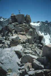
Richard and Tim can’t resist the race to be first up and, as
usual, Peter and I are struggling just to get there. There are several potential points on
the ridgeline that might be the pass. The correct one is to the right and slightly hugher
than the low point. On the north (Gardiner Basin) side there is only one spot without huge
cliffs, so it is essential to cross at the right place.
Breathtaking panoramas open to both the north and south. To the
south, the high rugged summits of the Kings/Kern Divide lace the sky. Northward you look
over the deep trench of Gardiner basin to peaks as far north as Mt. Goddard.
There were half a dozen other folks on the crest four teen-age boys
and two middle age men who were keeping their charges under tight control using whistles
and harsh commands, certainly no way to instill a love of the mountains in young men.
We downed M&Ms , water and peanuts and rested. A nap comes on
very easily after a hard climb.
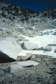
We started searching for a safe way to descend into the headwaters of
South Gardiner Creek since the first forty feet or so were almost straight down. I found a
rock-choked crack and descended it like a ladder. The others followed without any slips or
rock falls. The next thousand feet or so were very steep and rocky, but not vertical. We
found a cave under a rock overhang that we had used as a rain shelter during our trip
through this region in 1978. The route becomes a series of downward sloping granite slabs,
each of which must soon be abandoned because they invariably end in a cliff.
We made camp next to one of those granite slabs beside one of the
upper lakes in this canyon. Tim, as always, was first out with his fishing pole. We played
cards and after supper explored the geology of the region(especially the massive quartz
intrusions which must have made the early gold-seekers salivate). A huge rock-fall, across
the lake alerted us to the dangers of carelessness when selecting a camping site. We
marveled at the magnificent sights this glacially cirqued high lake basin presented at
sunset.
Tuesday morning we got away about ten o’clock for the pleasant
walk down through the series of lakes along the south fork, descending from granite bench
to granite bench, arranged like giant stepping stones, several of them harboring tarns or
marshy lakes. The forest cover becomes exclusively lodgepole, interspersed with verdant
clearings laced with colorful wildflowers. A trail passed 50 feet above the east edge of
the lower lake, and just beyond dropped in unbelievably steep zigzags to the floor of
Gardiner Creek’s main basin.To the left, hidden in forest and brush on a small flat
200 yards south of the creek, is the remains of one of Shorty Lovelace’s pigmy
cabins.
A hundred years ago mountains surrounding the San Joaquin valley were
filled with trappers, men who made a living by catching animals and selling their hides.
But Shorty Lovelace, the most famous trapper of the area, was one of a dying breed. Born
in 1886, he began his career in 1920. City life drove him to whisky and a perpetual
drunken stupor; only intoxicating mountain air could keep him from the bottle. He built a
small shelter in Crowley Canyon and began trapping weasels, fishers and other small
mammals for their pelts. Over a period of years, Shorty built a number of shelters, each a
day’s travel apart, with a line of traps in between. Like all trappers, Shorty worked
only in the winter, traveling on homemade skis, to get the pelts when they are thickest.
When spring came, Shorty would descend to the San Joaquin Valley and quickly sell his
winter haul for $2000 or more. But just as quickly he would spend the money on booze, or
lose it while drunk to muggers. So before long Shorty made it a habit t hand his earnings
to his brother, who would then ration it back to him for food and liquor. Shorty still
spent most of his summers drunk, but he occasionally returned to the mountains to work for
horsemen as a chef.
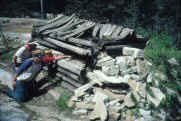
One estimate claims that Shorty built 36 shelters, most of them in
the Kings River drainage. His huts were scarcely ample for even his 5ft. 4 in frame, but
they no doubt served as solid bivouacs during winter gales. Some still stand including the
one in Gardiner Basin.
When Kings Canyon National Park was established in 1940, Shorty was
ousted to the North Fork of the Kings. There he trapped until the late ‘50’s
living a simple mountaineers life. He was last seen in his beloved Sierra near Roaring
River in 1961, two years before his death at age 77.
We speculated on that guy’s life, running trap lines every
winter by himself, moving from cabin to cabin every day or so. His cabins weren’t
built to stand the rigors of 100 winters, and one of these times, visitors will find
little, if any, evidence of his life style.
Just before leaving this idyllic spot I dipped my sierra cup into the
small stream rushing down the mountain nearby and noticed flecks in the sandy bottom.
“Gold!” says I. And all four of us became instant ‘49ers’ panning
‘gold’ with sierra cups. The stuff was very realistic, and we collected part of
a small vial full to be assayed back home.
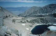
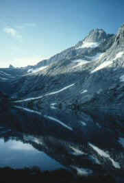
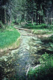
The trip up East Gardiner Creek to the lake basins that form its
headwaters is indeed magnificent. At the lower elevations the stream winds its
crystal-clear way through forested areas. Then, as we got higher, climbing over a series
of granite benches, it cascades over spectacular waterfalls. Finally we reach the
10,500-11.000 ft. series of lakes near timberline, each hemmed in by towering granite
walls.
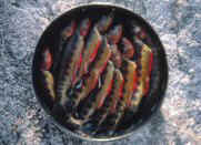
No other people but hundreds of hungry
golden trout as we spend the next two days at two of these lakes in the
Gardiner Basin. Just ‘lazy livin’ in the finest surroundings four guys could
ever imagine. Besides fish on the line with every other cast, we ‘enjoyed’ an
afternoon Sierra thunderstorm. The tube-tent-shelter Pete and Tim constructed kept the
rain off our heads pretty well, but the storm kept up long enough for a small river to
start flowing through our gear under the plastic canopy. No lasting damage, just lots of
scurrying around and a good test of our ponchos.
Finally on Thursday morning it was time to leave the Gardiner Basin.
The route was faintly ducked some of the way up to 60 Lakes Col near 12,000feet. On a
granite ridge between the last two lakes on this climb another thunderstorm broke. This
one tried to give us serious trouble—lightning and our metal pack frames were
inviting lightning rods on that high, exposed ridge; thunder that shakes you; icy wind
that quickly makes your exposed arms and legs shiver; and then hail stones that cover the
ground with1/4 inch or so in a few minutes. We found some protection in the rocks, shed
the backpacks and huddled as best we could for thirty minutes or so until the storm
passed. Just a vivid first-hand experience which leaves us all with much respect for the
high mountain county.
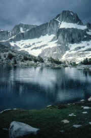
A long bolder hopping traverse got us past the north shore of the
highest and largest Gardiner Basin lake. Finally, the last of the climb ended at a saddle
called 60 Lakes Col between 12,721 ft. Mt. Cotter to the north and a 12,600 ft spire just
south. 60 Lakes Basin forms the panorama to the east
We dropped steeply down the snow fields and granite benches and
skirted the west shore of the highest of the “60 Lakes”. Now we see some folks,
the first since crossing Gardiner Pass, four days ago. There is a trail here that swings
northward through this string of lakes. We stopped for lunch here near a monolith called
Fin Dome, first named in 1899.
More light rain as we
crossed this area and made our way down to the beautiful Rea Lakes where there were at
least half a dozen groups of campers. We separated, each of us being sure we could find
the ‘best’ or at least a ‘suitable’ campsite. Richard was the last to
concede that the others had made the best selection. Pete and Tim arranged another rain
shelter. Rich and I walked to the stream, flowing from Dragon Lakes, for water. Tim tried
his best to get us to agree to take a route over Dragon Pass tomorrow as a way back to
Onion Valley. But there was no way he could convince me to try a class 3 knapsack route
over a 13,000 ft. monster.
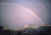
We enjoyed our last dinner while we watched the Painted Lady, Dragon
Peak and Glen Pass alternately colored by sunshine, storm clouds and even a double
rainbow.
Friday morning we started our last leg at 0830—1500 feet and two
miles up over rock and snow to Glen Pass. Rich and Tim again vied for first up and got
there in 90 minutes. Pete and I made the ridge about 15 minutes later. This is a very
strenuous climb so we were elated to have made it so quickly and with such apparent ease.
Its another two miles down to the junction just east of Charlotte
Lake, then a seemingly endless (3 miles) climb up to Kearsarge Pass.
Besides the fat ground squirrels that scurry boldly for crumbs dropped by hikers, a guy
with a fancy short wave receiver was demonstrating its prowess on the pass.
We all felt kind of superior—well conditioned and very
trail-wise as we passed a lot of the “fortunate 60” sweating and puffing their
way up the Keasarge Pass Trail that afternoon. Male/female, fat/thin, young/old, well/ill
equipped—all kinds sample the trails and enjoyment to be found in the Sierra.
Back to Onion Valley we unpacked our feet from those heavy, dusty
boots to let our toes recover in the fresh air, packed all the gear in the trusty yellow
cars, and wound down the 15 mile road to Independence. Two pieces of business there: call
Eva so she wouldn’t faint when four tramps showed up for dinner, and getting
six-packs to quench our week-long thirsts for Bud and Coke.
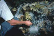
Rich said
“There’s no way my hot water heater can accommodate all the grime on our
hides” so we stopped at Keogh hot springs just south of Bishop. We took a dirt road
off #395, parked at the end, walked a short way to the stream, and stripped like it was a
private place (which it wasn’t). That stream bubbles out of the ground at about105
degrees F, and was a great way to clean up and relax sore muscles.
Eva, as always was the gracious hostess for our steak, spuds,
asparagus, salad, wine dinner. The next door neighbors visited with a big ‘baby
Templeton’ cake before we spread our bags one more time (one on the front lawn) for
the last night of the trip.
Gardiner Basin Bibliography
Shorty Lovelace, Kings Canyon Fur Trapper
William C. Tweed
1980 Sequoia Natural History Association
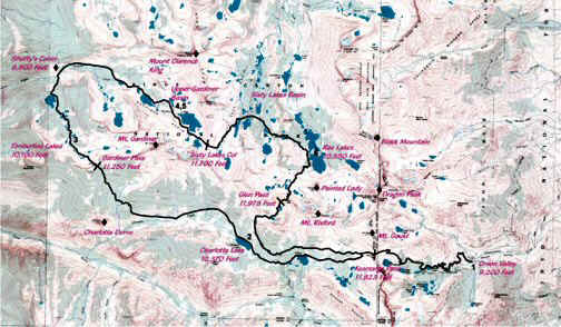
Gardiner Basin, California, Topographic Map
Created by –myTOPO.com, for
J.A.Templeton, June 9, 2003
Beartooth Mapping, Inc
POBox 2075
Red Lodge, Montana, 59068
High Sierra Hiking Guide #14
Mt. Pinchot Central Kings Canyon
Park
John W. Robinson
Wilderness Press, Berkeley
Mountaineer’s Guide to the High Sierra
Edited by Hervey H. Voge and J. Smatko
Sierra Club
,Keywords
High
Sierra, Onion Valley, Kearsarge Pass, Glen Pass, Charlotte Lake